Why choose aerial estimation for satellite roof measurements?
We are certain that once you see the benefits of our roof report and complete summary of each facet, you will never go back to old fashioned roof reports again. Aerial Estimation is the most complete source for all your Satellite Roof Measurements. We know what contractors want.
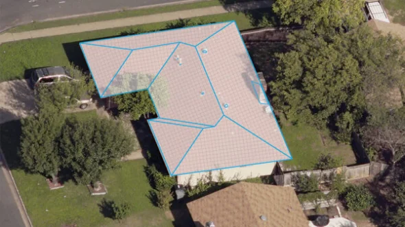
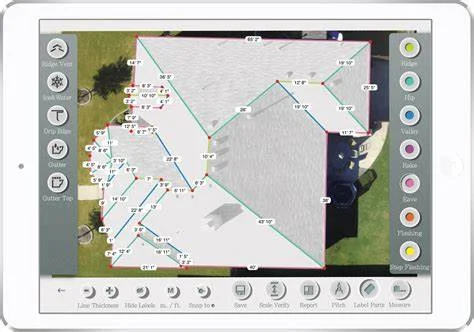
Roof Measurements including Area, Rakes, Ridges, Hips and Valleys, and every edge is separately measured and identified. You guys have been great providing quick and accurate reports, and your tech support has been amazing as well! If you’re looking for a Professional measurement on a project before beginning, this is your site.
What is the best roof measurement service?
Sky Roof Measure is the complete aerial roofing measurement service that delivers roof measurements in under 1 hour for single-family homes, and under 24 hours for multi-family and commercial properties. For as little as $12 a report, it’s the only roof measuring tool you need.
How are your aerial roof measurement reports prepared and verified?
Our aerial roof measurement reports are prepared by trained CAD technicians followed by a 3-step verification process by a quality assurance professional, certifying absolute data accuracy on every report we deliver. A wise man once said: “When you arrive empty handed, you’ll return empty handed”.
What are the different types of roof reports?
Report types: Roof Diagram, Aerial Timeline, Hail Report and more. More than 275,000 Roof diagrams completed across the United States. At Sky Roof Measure, we pride ourselves in making your job easier and more effective. Our high quality imagery allows us to create accurate and specific roof reports.
Ensuring aerial data can be modified as needed is key to optimizing productivity and efficiency. Suppose a homeowner changes their mind about the scope of a project—if a contractor is using static measurements and reports, it can take hours to revise. But with aerial data integrated into estimating and reporting solutions, changes can be made quickly and updates reflect immediately. Giving crews the ability to modify reports on the fly reduces delays and improves workflow.
With training and the right tools, contractors can use aerial data to increase productivity and make a strong case for why insurance carriers and homeowners should rely on them to accurately estimate damages and restore the property to its pre-loss condition swiftly.