drone

Drone Technology for Roof Inspection

According to roof inspection companies, using a drone allows them to finish jobs three times faster than if they did them using traditional methods. This capability also lets them offer more premium services because they can commit to shorter turnover times and more detailed roof inspections reports.

Nationwide, they cost an average of $150 to $400. The inspector flies a drone equipped with a camera over the roof, capturing close-up footage of all surfaces for the expert to analyze.

Call us : (315) 926 1777

Email: info@skyroofmeasure.com

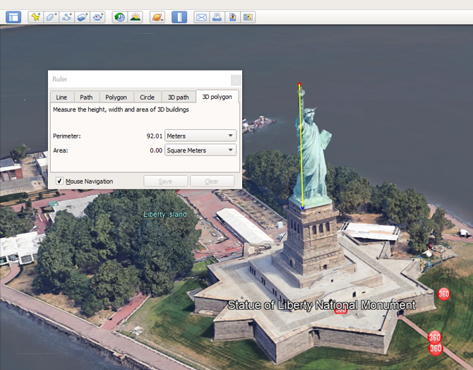
Do roofers use drones?

Drones used in roofing inspection is increasingly common across North America. Held in high regard in the construction and building inspection industries as well, drones in roofing have significant value. They make the inspection process go faster, lower costs, and there is no risk involved.
 
Increase productivity and improve safety. An aerial drone roof inspection can speed up the inspection process, and reduce the risk of work accidents and damage to the client’s property. It is also incredibly precise, with drone roof inspection measurements 95% accurate.

Drones Get the Job Done Faster

Any roof inspection requires a great deal of planning and preparation. Much of this is dedicated to ensuring the safety and compliance of workers.

With drones, however, it’s easier to carry out an inspection shortly after a client makes the request. Because drones don’t mount and climb access equipment, drone-based examinations begin immediately and take a fraction of the time of conventional methods.

Additionally, drones can transmit data to the inspection team immediately, which allows for faster report generation and less risk.

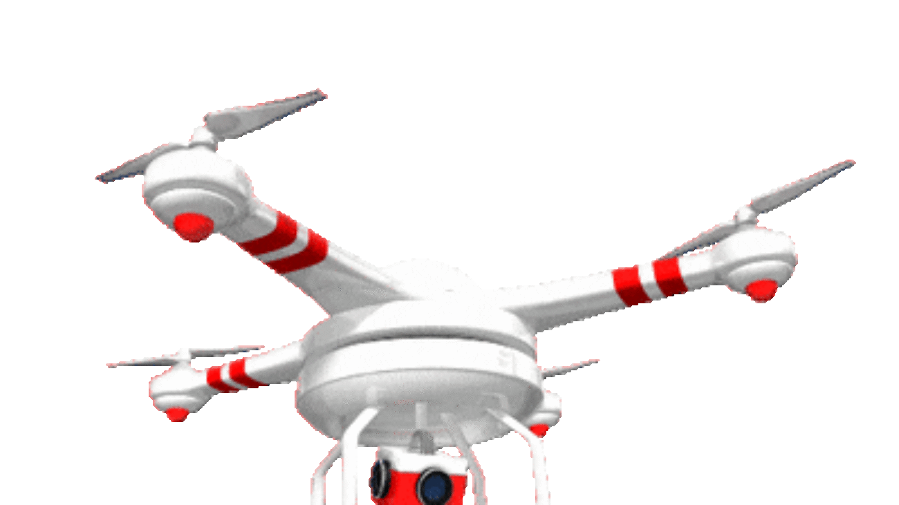
Features to look for in a drone for roof inspection:

  1. Flight stability – One of the most important features for drone roof inspection is stability. The drone must withstand the prevailing weather conditions including moderate and strong winds.
  2. High-resolution camera – When doing a roof inspection, you would want your videos and photos to be as detailed as possible. Nowadays, recording videos for professional use at a resolution below 4k is already unacceptable.
  3. Obstacle avoidance systems – To capture detailed shots or footage of a roof. Drone must fly close and low. It is not recommended to a drone to fly autonomously if it doesn’t come equipped with a good obstacle avoidance system.
  4. Thermal Camera – Thermal imaging cameras of drones allows inspectors to scan large areas for moisture trapped underneath roof membranes and look for the effects of structural issues. The thermal camera detects this temperature difference and displays it as colors – for example, dark tones indicating cold moisture or light tones indicating heat escaping through the uninsulated roof.
  5. GPS guidance/Satellite Positioning – Not only does it make controlling your drone much easier, but it also paves the road for many other advanced features which can be of great help, especially for a roof inspection. GPS allows several other smart flight modes including Orbit, Follow Mode, Waypoints etc.
  6. Long battery life – The longer the battery the better. Any drone that can fly for 25 minutes or more on a single battery cycle should do.
roof quotes online

Measure My Roof

Measure the length of the roof at its base along one side of your house. Use a ladder, if necessary, to get the most accurate measurement. Measure along the roof’s angle to get the width of your first roof area. Multiply the length by the width to get the area in square feet. Follow us for more details please.

Sky Roof Measure provides accurate roof measurements in .esx format, for use with Xactimate, at affordable prices. We now also provide wall measurement reports in PDF format .

Call us : (315) 926 1777

Email: info@skyroofmeasure.com

Our service is quick and easy to use.  Sign up for a free account today and ordering is as easy as 1, 2, 3!

  1. Enter the address where you need a measurement on the home page, and confirm the location on the satellite map view.
  2. Choose the type of report you need – commercial or single family home and/or wall report – and add any special instructions.
    • Add your reference number or claim ID to the order for easy tracking.
    • Let us know if you have special requirements, such as including secondary structures on single family home orders.
  3. Confirm your order and checkout.  You can also order multiple reports on a single invoice including an entire campus. 

Most customers pay by credit card.  Let us know if you need to pay by check.

How to use the google maps area calculator tool to measure a roof

Special precautions must be taken when measuring the area of a roof. The images that appear on google maps are often at a slight angle, which combined with the angle of a roof can cause errors. For this reason it is best to outline the roof at points which are all at the same elevation. On a simple house for instance you would only click on the corners of the roof and not on any points along the peak as that would cause an error. After measuring the area of the footprint you can estimate the actual roof area based on the angle of the roof. Similarly if you using the area calculator tool to measure a roof with multiple levels, you should do the individual section separately. The google maps area calculator is not 100% accurate. Do not rely on this tool as your only resource in making important decisions.

How to Get Your Satellite Roof Measurements

You’re a few simple steps away from your aerial roof measurements (and a better back!):

    • Enter Your Details: Give us your name, email, and phone number so we can contact you.
    • Enter Your Address: Let us know which roof to measure.
    • Leave Notes: Tell us to exclude the garage or anything else we should know before sending your measurements.
  • Confirm Your Address: Hey, we just want to know we’re measuring the right house!


That’s it! Just proceed to the payment page (if necessary), and you’ll get your measurements instantly. See, wasn’t that way better than spending all day on the roof in the hot sun?

From there, you’ll create your free toolbox account where you’ll have access to your measurements and a ton of tools to make your roof project easier, cheaper, and faster.

roof blueprint

Roof Measurements

Satellite Roof Measurement

One reason why measuring a roof by satellite is so accurate is due to the fact that you have as high and clear a vantage point as is possible. You can zoom in as much as you want, depending on the tool used, and everything is easy to see and put together. In other words, there’s no way to get any higher or see the roof from any better of an angle than from far above in a satellite.

Roof Measurements from Satellite

Another thing that helps to enhance the accuracy of satellite roofing measurements is the combination of pairing the satellite photos with software to help get the best and most accurate measurements possible. By starting with such good photos, strong software designed for the purpose can help ensure accurate measurements of the roof.

That’s why it’s so important to make sure you use the right software. Its accuracy will depend on its capabilities. But, it will also depend on its inputs. IN other words, one of the reasons why the satellite approach is so accurate is because it has fantastic inputs from the satellite photos. Otherwise, this accuracy wouldn’t be where it is.

Roof Measurements With Google Earth

  • On your computer, open Google Earth.
  • Search for a place, or select a location on the globe.
  • On the left, click Measure. . …
  • Click the map to set measurement points.
  • To remove a point, on the right, click Undo .
  • To complete your line measurement, double-click on your last point, or click Done .

How to Get Accurate Aerial Roof Measurements?

How to Get a Roofing Measurement
  1. Measure the width and length of each plane of the roof (including dormers), and then multiply those numbers to get the correct figure for the square footage of that area.
  2. Note any skylights, chimneys or other parts of the roof that would not require materials so you can subtract those measurements from your total area.

How do you measure a flat roof?

Just measure the length and width of each plane on the roof, including dormers. Then, multiply length x width to get the square footage of each plane. Simply add the square footage of each of the planes together to derive the total square footage of your roof. For example, this flat roof has one roof plane.

Rooftop Measurements

  • Prepare roof measurements and professional estimates from anywhere.
  • Print email and share digital reports with property owners or with your team. 
  • Eliminate unnecessary trips to the job site. 
  • Spend less time on roofs and more time with customers face-to-face.
  • Impress clients with new roof simulations, roof diagrams and other visuals.

How to Measure Roof Slope from On the Roof

To use the direct roof slope measurement procedure, in addition to safe access to a roof that won’t be damaged by touching or walking on it, you need: a tape measure and a carpenter’s level. This procedure to measure roof slope can be performed on the roof or from a ladder at roof edge. 

  • Hold the carpenter’s level in a horizontal position with one end touching the roof surface.
  • Measure out 12″ along the level bottom edge – the green line in our sketch. Mark this point on the leve.
  • Measure straight down to the roof surface from the mark you just made – the blue line in our sketch.
  • Read that distance in inches. The result is inches of rise per foot of run.

How to Manually Measure a Roof

  1. Measure the width and length of each plane of the roof (including dormers), and then multiply those numbers to get the correct figure for the square footage of that area.
  2. Note any skylights, chimneys or other parts of the roof that would not require materials so you can subtract those measurements from your total area.
  3. Add together the calculated square footage of each surface to get the figure for total square footage of the roof.
  4. After determining the total square footage of the roof, you must calculate the pitch of the roof by measuring the vertical distance (rise) over a 12 inch horizontal segment (run).
  5. Write down these numbers as the vertical measurement listed first and the horizontal measurement recorded second so you can find rise over run.
  6. When you have the total square footage and rise over run of the roof, you can calculate the roof squares to determine how much materials are needed to cover the roof. To calculate the number of squares on a roof, you need to divide its total square feet by 100.
Aerial measurement

Drone Roof Inspections – How to Do Roof Inspections with a Drone

How much does a drone roof inspection cost?

Drone roof inspections: $150-$400

Nationwide, they cost an average of $150 to $400. The inspector flies a drone equipped with a camera over the roof, capturing close-up footage of all surfaces for the expert to analyze

Can drones measure roofs?

Drones present a unique opportunity for getting a clear view of your rooftop and allowing you to get precise roof measurements. A variety of roof measuring applications and programs already take advantage of high-resolution drone imagery to get accurate roof measurements.

How much should a roof inspection cost?

On average, a roof inspection costs $212. Most homeowners pay between $119 and $307 for an inspection, although that range can go as high as $600. Your budget might change for specific types of investigations like drones or infrared.

Increase productivity and improve safety

An aerial drone roof inspection can speed up the inspection process, and reduce the risk of work accidents and damage to the client’s property. Aside from the time and effort needed to to climb a roof, lots of manual measurements and accurate photo acquisitions are required.

An aerial drone roof inspection can speed up the inspection process, and reduce the risk of work accidents and damage to the client’s property. It is also incredibly precise, with drone roof inspection measurements 99.4% accurate. Aside from the time and effort needed to climb a roof, lots of manual measurements and accurate photo acquisitions are required.

The best drone software for measuring roofs

IMGING is one of the best tools around if you’re considering getting into performing measurements for your construction needs or if you want the perfect solution for measuring your roof using your drone.

DroneDeploy is a versatile software solution that can be used in a broad variety of situations, ranging from creating customizable 3D maps using images picked by the drone to inspecting roofs, performing roof measurements and generating comprehensive reports from the findings.

EZ3D is one of the best drone software solutions for construction and roof measurement that you can use from both your computer and your phone. You can use this tool, or better said, this ensemble of tools, to inspect, measure and analyze roofs with consumer-level drones.

As you probably figured out from the context, EZ3D can’t be used without a drone. According to the producer’s website, any standard DJI drone will do the trick.

Pix4D is certainly one of the best all-round drone software solutions for all your construction needs, whether it’s surveying your construction site, performing measurements on buildings, or assessing the wellbeing of your roof we’re talking about.

Relevant Article –

roof blueprint

Can drones measure roofs?

Drones are an increasingly popular tool used by home inspectors. … These regulations require any person operating a drone outdoors for a commercial purpose to obtain a Remote Pilot Certificate (RPC), register their drone, and follow certain requirements when operating the drone.

Can drones measure roofs?

Drones present a unique opportunity for getting a clear view of your rooftop and allowing you to get precise roof measurements. A variety of roof measuring applications and programs already take advantage of high-resolution drone imagery to get accurate roof measurements.

     Call Us +1 (940) 233-5566

How much does a drone roof inspection cost?

Drone roof inspections: $150-$400

Nationwide, they cost an average of $150 to $400. The inspector flies a drone equipped with a camera over the roof, capturing close-up footage of all surfaces for the expert to analyze.

Applications range from real estate photography to building inspection and drone operators can charge from $200/hr to $5,000 per session. It does not really cost you any money to fly your drone or edit the footage, so your price will be determined by the value you provide instead.

How much does it cost to hire a drone pilot?

Pilots usually charge around $100-$150 per man hour. The amount per hour, and number of hours depends on several factors including: How many hours the pilot will need to be on site.

Who pays for new roof buyer or seller?

For one thing, you can ask to have the seller pay for a new roof and you’ll increase the amount you pay for the house. You can, on the other hand, ask the buyer to lower the asking price for the home so that you can include a new roof in the budget

How much should a roof inspection cost?

On average, a roof inspection costs $212. Most homeowners pay between $119 and $306 for an inspection, although that range can go as high as $600. Your budget might change for specific types of investigations like drones or infrared.

Why can’t drones fly in national parks?

Put simply, the NPS banned drones in national parks because they can be disturbing to both people and to wildlife. The drone ban the NPS issued in 2014 came after several individual bans had been made at various national parks throughout the U.S.

Is drone photography profitable?

Earn money selling aerial photos and footage. One of the most common ways to make money with drones is selling the aerial pics and videos to people. Drone photography can be quite a profitable business and it is very popular nowadays. … On the other hand, you can make custom aerial footage and take photos by commission.

Do home inspectors have to climb on roofs?

Home inspectors will gamely climb onto your roof and check for missing or warped shingles and make sure flashing and gutters are in good shape. There’s one huge caveat: Your roof should be less than three stories tall and not too steep. If it is, they’ll probably pass. … “We’ll go up on roofs if it’s safe,” says Lesh.

roof quotes online

Roof Measurements From Satellite

Aerial Measurements For Roofing Contractors and using Google Maps to get unlimited roof measurements can help any roofing contractor, and be more efficient. Most roofers feel like they need to go to every estimate and then measure the roof, and most of the time it’s a good idea to go to every estimate, but this free tool will give you the opportunity to do a little homework before you get to the job.

                            Call Us – (315) 926-1777

Satellite Roof Measurements 

Our  roofing contractors are able to receive measurements of any roof in a very short time with extreme accuracy without the need to visit your home or business. Our aim is to provide you with all the necessary information to enable you to make informed decisions. 

Saving Precious Time

It also happens that roofing issues can sometimes become roofing emergencies so utilizing satellite roof measurements can speed up the process of repairing your roof. There is no need to book appointments in advance to have our roofers visit your home in order to physically take measurements and conduct calculations in order to provide you with an accurate estimate. Our foam roofing experts receive all your roofing measurements electronically and prepare your free no-obligation estimate in the shortest time possible.

How Satellite Information Is Received 

Satellite roof measurements are based on satellite images sourced from Google application programming interfaces (APIs) that receive information and images from Google Earth. The information and images are used to calculate accurately both the square footage and slope of your roof. It is no longer necessary to have individuals climbing on your roof to take physical and time-consuming measurements.

The Roof Measurement Report provides a detailed analysis of your roof layout and all the critical dimensions. Our full color report provides the detailed lengths, pitch and areas of every surface plane and edge. This report saves your time and enables accurate roof estimates for a roof repair or replacement. This is a professional grade report used for use by licensed roofing contractors or insurance companies. You will receive the report in .PDF format by email within 1-3 days.

What factors determine the price of a roof?

Type of Roofing  –  The material type that you purchase for your roof affects the bid price. There is a basic 3 tab or 3 in 1 style, Architectural or Laminated (Most Common) and then you designer or premium level shingles. Each of the major manufacturers will have their own individual characteristics, the thicker the shingle the heavier it will be rated for durability.

Pitch – The steeper the roof the steeper the price! Steeper roofs require additional safety precautions and create slower installation speeds. This additional labor required will add to the total cost of the job.

Height – Similar to the roof’s pitch affect on price, the higher the roof typically the higher the price. Most companies will charge an additional amount for 2 or 3 story access.

Allowance For Growth And Change

Since technology has thrived over the past few years and is consistently growing and changing, using satellite imagery allows for the ability of homeowners and contractors to grow and change with reducing risk and potential damages that could occur when obtaining roof measurements. In addition by getting more accurate readings and measurements on the roofs, the expenses that are required are reduced as they are more accurately acquired and they take fewer visits to obtain the calculation or measurements. In addition, satellite measurements have the ability to give homeowners the exact square footage even though the slopes and steeps of the home. This can increase contractors companies proficiency and accuracy to help homeowners increase the longevity of their homes because the repairs will be done more professionally. Moreover, contractors and homeowners can measure roof from a satellite for free with the programs that are available online, thus saving them time, claims, flexibility, and materials for roofing jobs.

roof blueprint

Drone Roof Measurement Software

Drones are one of the hottest topics in the roofing industry today. The idea of using a high-tech flying camera to reduce your time spent on dangerous roofs is too tempting to ignore.

Why buy a drone for your roofing company?

  • Inspect difficult to access roof sections & reduce time spent in the “danger zone”
  • Create detailed aerial measurement reports
  • Create professional quality footage of your projects that you can use later in your marketing material
  • Make a lasting impression on your customers & close more sales
  • Have fun at work & trick everyone into thinking you are a serious professional and not a big kid with a new toy.

Call Us for Roof Measurements : (315) 926-1777 

OR  Email us : info@skyroofmeasure.com

Drone Roof Measurements

The rising popularity of drones in the roofing industry is no accident. Professional contractors everywhere are seeing the advantages of merging technology with their toolbox; allowing increased safety, higher accuracy, less headaches, and the type of modern presentation clients now expect. Simply put, combining high-resolution drone imagery with a powerful roof measurement application means more sales. The days of spending 30+ minutes on a roof to calculate measurements – only to lose the bid – are becoming a thing of the past.

Roof inspection may sound like a mundane job, but it can be a pretty lucrative venture for a drone pilot. Drones can totally change up the way that roof inspection jobs are done. They’re safer, more efficient, and require much less equipment. Best of all, there’s potential for you to come up with much more detailed inspection reports and 3D models when you use drones.

To produce results of professional quality, you’ll need a combination of the right drone and a good roof inspection software. There are a host of them out there – roof top inspection isn’t the most technically demanding use of drones, after all.

Drones eliminate the need for using a ladder, reducing the likelihood of accidents. Using a drone is also a more cost-effective method to obtain information, which can help you create efficient roofing solutions. It is also three times faster than a traditional roofing inspection. 

Cost-saving

The drones can save inspection costs in many ways. It cuts down on equipment requirement, labor and time. By eliminating the need to use ladders and other heavy climbing and access equipment, it reduces the need to purchase or hire them as well as the risks. Consequently, this eliminates the need to insure the workers and the equipment.

A manual method would take hours or days to plan, prepare and collect the data from a roof. On the other hand, a drone can do the same and even better in less than one hour at lower costs, and reduced safety and health risks.

Conclusion

Drone-based roof inspections are more safe, faster and cheaper. Also, they enable the inspectors to collect a wide range of data which is also more accurate. Usually, the traditional manual methods have several limitations and companies may avoid them due to the high costs, more risks, and time-consuming inspections.

On the other hand, the drones provide cost-effective assessments that are also faster, hence enabling the organizations to carry out more inspections.

drone

Drone Roof Measurements : Roof Inspections

The rising popularity of drones in the roofing industry is no accident. Professional contractors everywhere are seeing the advantages of merging technology with their toolbox; allowing increased safety, higher accuracy, less headaches, and the type of modern presentation clients now expect. Simply put, combining high-resolution drone imagery with a powerful roof measurement application  means more sales. The days of spending 30+ minutes on a roof to calculate measurements – only to lose the bid – are becoming a thing of the past.

                      Call Us – (315) 926-1777

Why Use Drones for Roof Measurements?

One of the main benefits of drones is their size and maneuverability.  This feature allows them to fly a few feet away from various building types and capture high-resolution imagery for residential, commercial, flat and metal roofs.

How Does it Work?
Once a drone inspection has been completed by a pilot in our on-demand network or by an in-house carrier pilot using our drone inspection software platform, all of the photos from the inspection are encrypted and uploaded into our cloud storage system.  Photogrammetry software, powered by a lot of computing power, processes this imagery into a 3D point cloud, 3D model, and 2D  map (think Google Maps but much higher resolution). The 3D point cloud data is then interpreted to produce measurements, such as:

  • Perimeter
  • Surface Area
  • Pitch

Drones eliminate the need for using a ladder, reducing the likelihood of accidents. Using a drone is also a more cost-effective method to obtain information, which can help you create efficient roofing solutions. It is also three times faster than a traditional roofing inspection. 

Minimizes Workplace Hazards

Did you know that falling is the leading cause of death on construction sites? Using drones minimizes the risks for potential injuries and mishaps that can happen to dedicated teams of construction workers. In case specialists miss important information, they won’t need to return back to the site just to collect data.

Drones have become a valuable resource to not only increase efficiency, but to also keep employees from needing to complete dangerous tasks and out of harm’s way.

That’s never been more critical than during the current COVID-19 pandemic, where drones have become a vital resource that allow companies to continue operating while facing disruptions to their labor force as well as observing the need for social distancing amongst their employees.

How to Get Accurate Aerial Roofing Measurements?

How to Get Accurate Aerial Roof Measurements?

Planning to climb the house to calculate the square meter manually? Every time you prepare an estimate means you can only cover so much ground after a big storm. It takes time to measure every area and input the information into an estimate, setting you back hours a day.

Sky Roof Measure gives you easy, detailed, and meticulous reports of the roof measurement, so you don’t have to waste time measuring the roof manually. Get precise measures for your roof and summoning of projects directly with the celestial point on the roof, saving time and a twist to a more rapidly.

Save Time, Cover More Ground with Aerial Measurement Reports

Ordering aerial roof measurement reports is a much quicker and more convenient way to measure your roof. Instead of climbing the ladder to measure the roof manually and enter the measurements, the whole process can be eliminated while we measure for you, saving time and the debugging of the measurements for you.

Deliver estimates faster

After the big storm, you want to be as ready as possible for the job inflow. The customers are eager to repair their homes, so as soon as you give the estimate, it can begin quickly. Even a regular roof can take several days. In addition, you risk incorrect numbers. Unlike that, orders through Sky Roof Measure roofing takes only a few hours, which means that your sales teams on the ground can estimate more homes.

Eliminate errors

Measuring a shingle roof is a procedure that is subject to errors and sometimes results in miscalculations. Our Aerial measurement reports eliminate manual errors so you can be assured you have accurate numbers from the very start. Eliminate material shortages and overages once and for all, with Sky Roof Measure reports, thus saving money for your roofing business.

Join the revolution of aerial roof mapping

Up your roofing workflow and start working with high-res, current imagery of your worksites and properties. Get the advantage of Sky Roof Measure aerial reports content customized with your logo and other desired details to empress your clients and add value to your company.

Satellite and Drone imagery

Difference: Satellite and Drone Imagery

Satellite and Drone Imagery: Comparing satellite imagery with today’s aerial imagery isn’t as easy as it once was. All factors are advances on many fronts including computing, infrastructure, information, hardware, and software not to mention the cost. Perhaps the best analogy lies in aligning convergence toward usefulness for each of these.

Roof measurements need to be accurate and precise, this requires High-resolution imagery and 3D representations.

Accurate Roof Measurements

Drones can obtain faster and more accurate Imagery than satellite imagery and for timely assessment of the property to provide immediate feedback to the client to take action. Historical data detection helps diagnosis and corrective action. 

High-resolution Drone-based imagery allows for much better identification, evaluation, continuous monitoring, and corrective action than satellite imagery with low resolution. On the other hand, satellite imagery helps for vast site measurements and historical data analysis.


Drone Roof Measurements  : Sky Roof Measure

But the differences in revisitation are critically important. And these decisions are highly oriented to the application at hand. It is now hard to imagine clients accepting imagery of any kind only with low-res imagery and basic satellite site mapping report. Satellites offer resolutions ranging from 30 cm to several meters. In general, the higher the resolution offered by a satellite, the lesser territory its images will cover. 

Satellites and drones in the air are not opposite technologies, in fact, the two sources of information are used to power similar applications and their data can be complementary. This is why Sky Roof Measure combines satellite and High-resolution 3D imagery to provide in-depth and diverse data for your customers.

More Relevant Pages :

Roof Measurement Service Atlanta City, NJ

Roof Measurement Trenton, NJ

Roof Measurement Service Ocean City , NJ