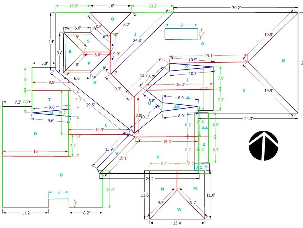
roof quotes online

What is an Aerial Roof Measurement Report

In most cases, satellite and aerial roof measurement technology is 99% accurate, if you follow a few simple rules. Achieving accurate roof measurements manually isn’t any different. A manual roof takeoff by one roofer can easily vary from that of another.
Measure distances and areas in Google Earth
a2 = b2 + c2 – the square of the length of the hypotenuse (a) equals the squares of the lengths of the opposite sides of a right triangle (b) and (c). Given a2 we use our calculator to take the square root and bingo, we have the length of the sloping side of the roof.
To calculate your roof area, simply multiply your roof length by your roof slope height, and multiply this by two. This should give you the total area of your roof, not accounting for a chimney or other sections of your roof not covered by tiles.
If you know the roof’s angle in degrees, you can find the roof pitch by converting the angle in degrees to a slope, then finding the rise by multiplying the slope by 12. First, find the slope by finding the tangent of the degrees, e.g. slope = tan(degrees). Then multiply the slope by 12 to get the rise.
 

Sky Roof Measure provides industry leading takeoff and  Roof Estimating Reports for professional construction contractors. Please Email : info@skyroofmeasure.com

roof blueprint
A roofing square is an area of roof that measures 10 by 10 feet to make up a total of 100 square ft. This critical unit of measurement helps your contractor determine how much material they’ll need to order for your roofing project, from underlayment to bundles of roof shingles.
Multiply the effective length and width of the sheet to obtain the effective surface area. For example, if the effective width is 2.5 feet and the length is 7.5 feet, multiply 2.5 by 7.5. The result, 18.75 square feet, is the area each sheet will actually cover.

Looking for a Roof Measurement Report?

roofer

Aerial Estimation | Aerial Roof Measurements | Aerial Roof Measurement Reports

Aerial Estimation is the most complete source for all your Satellite Roof Measurements. We know what contractors want. Roof Measurements including Area, Rakes, Ridges, Hips and Valleys, and every edge is separately measured and identified.

How are your aerial roof measurement reports prepared and verified?

Our aerial roof measurement reports are prepared by trained CAD technicians followed by a 3 Step verification process by a quality assurance professional, certifying absolute data accuracy on every report we deliver. a wise man once said ” When You arrive empty handed, you’ll return empty handed”.

How accurate are roof measurements?

In fact, our roofing measurements have been proven accurate to within 2%-5% and fastest report delivery compared to other Aerial Roof Measurement Companies. Don’t Hand Measure a Roof, Get A Roof Report Using Accurate Satellite Roof Measurements at Sky Roof Measure.
Measure distances and areas in Google Earth
Roof Dimensions Google Maps

What is aerial estimation?

Aerial Estimation is the most complete source for all your Satellite Roof Measurements. We know what contractors want. Roof Measurements including Area, Rakes, Ridges, Hips and Valleys, and every edge is separately measured and identified.

What types of images do our roof reports support?

Multiple image providers for over 98% coverage of the USA & Canada. Also supports file formats such as XML,RFX,DFX/DWG, ESX AND WRL. Our roof reports start at under $13 with no set-up or membership fees.
aerial roof measurement

Our Goal & Specialization

Our goal at Sky Roof Measure is to streamline your day to day operations by automating your employees and allowing them to work more efficiently with the help of our interactive Roof Reports. When your roof report is ready, it is not just emailed to one person, or available for download into a single desktop application, it is available to anyone in your company using a web based user account. All your reports saved on our database and you can view and download any time as per your convenience. Our 3D Roof reports include Aerial Images, rakes, flashing, valleys, ridges, multiple slope areas, pitch, linear measurements, total squares, recommended waste, etc. Our System can Export and import file formats such as XML,RFX,DFX/DWG and WRL.

AERIAL ROOF REPORTS Affordable roof measurement services for roofers, general contractors, builders, and distributors in the U.S and Canada.

How are blueprints measured? Unroll the blueprint onto a flat surface. ... Find the scale of the drawing. ... Choose a scaled ruler that accurately matches the scale of the drawing. ... Lay the proper scale next to the item on the drawing and take the measurement.

Aerial Roof Measurements, Roof Images

Aerial roof measurement report

The Roof Measurement Report provides a detailed analysis of your roof layout and all the critical dimensions. … This report saves your time and enables accurate roof estimates for a roof repair or replacement. This is a professional grade report used for use by licensed roofing contractors or insurance companies.
 

How do I get an accurate roof measurement?

Measure the base area of your property

That will be the roof base width. Then, measure the distance of the other side of the structure from the edge of the eave to the other. That will be the roof base length. Multiply those figures together to get an estimate of the base area for the roof structure.
 

How do I figure out how many square My roof is?

Roof surfaces are measured in “squares”. A roofing square is equal to 100 square feet of the roof. To determine the number of squares on the gable roof example in this post, divide its total of 2400 square feet by 100 (2400 ÷ 100 = 24). This means you would need 24 squares of shingles to cover that roof.
 

Can I measure my roof from Google Maps?

The good news is there is a way to measure your roof in a safe and accurate way, all from the comfort of your home: use Google Earth. With just a few clicks, you can search for any address, get a bird’s eye view of your roof, and get the roofing measurements that you need.
 
Average Cost to Replace a Roof by House Size
House (& Roof**) by Square FootRe-Roofing Cost*
1,000 (1,054)$4,000 – $5,500
1,100 (1,160)$4,200 – $6,000
1,200 (1,265)$4,500 – $6,500
1,500 (1,581)$5,500 – $8,000

What is the cheapest way to replace a roof?

Asphalt Shingles – The answer to what is the cheapest roof to install is asphalt shingles. This is the most commonly used and least expensive of roofing shingles.
 

Is it OK to reroof over old shingles?

Installing a new roof over shingles takes less time than tearing off the old roof. Looks just as good and lasts as long. As long as it’s done right and under the right conditions, installing new shingles over old ones can last as long and look just as good as a complete re-roof. Has the same manufacturer’s warranty.
 

How long does a 30 year roof really last?

The expected service life of a 30-year product, if properly cared for, is approximately 25 years. If it’s not cared for properly, that 30 year shingle will only last 12 to 15 years. That’s one of the big misconceptions in the roofing marketplace.
Roofing material that lasts the longest are concrete, clay or slate tiles. These materials significantly outperform other natural products like wood shakes or any manufactured roofing materials including asphalt shingles and metal roofing.
 
aerial roofing

Accurate 3D Aerial Roof Measurements Reports

At Sky Roof Measure we create accurate 3D roof models from intelligent aerial images and generate a detailed PDF report. We generally serve Roofers and Insurance Professionals.

                                   Call Us +1 (940) 233-5566

We have extensive training and experience in the interpretation of aerial imagery and the creation of ACCURATE 3D roof models, our process includes; fetching aerial images > creation of the roof model > generation of PDF report.

We began producing 3d roof models from January 2010, we offer consulting services in regards to software selection and human resource training for other companies within the aerial roof measurements industry.

By combining multi-angle aerial images with advanced analytics, our reports provide precise area, pitch, and length measurements. Colour coding distinguishes every detail, from ridges, hips, and valleys to verges, eaves, and flashings. Fast report turnaround saves you time. High-resolution aerial views and 3D diagrams make your tender stand out.

Our roof measurement reports provide a detailed overview of every aspect of your roof. Each report comes with aerial images of the property, a 3D diagram of the roof, length, area, pitch and notes diagrams, as well as a summary page with waste table calculations. Our EagleView generated reports include length diagrams with color-coded details and total lengths for ridges, hips, valleys, rakes, eaves, flashing and step flashing. The Wall Measurement Reports provide a detailed analysis of your wall layout and all the critical dimensions, including the area each wall feature These professional-grade reports are used by all types national companies and come with an Accuracy Guarantee. All the measurement’s final report will emailed to you within 1-4 days.

Why Use Drones for Roof Measurements?

One of the main benefits of drones is their size and maneuverability.  This feature allows them to fly a few feet away from various building types and capture high-resolution imagery (sub-centimeter per pixel resolution) for residential, commercial, flat and metal roofs.

Features / Application / Technical Info.

    • 3D Roof Diagram
    • Aerial Images (Top, N, S, E & W)
    • Length Diagram
    • Pitch Diagram
    • Area Diagram
    • Notes Diagram
    • Report Summary
    • Waste Calculation Table

Aerial Reports is a quick and easy way to get detailed and accurate roof measurements anywhere you want without leaving your office. Aerial Reports uses the best of the industry’s Proven off-the-shelf software and available aerial imagery to provide Roofers, Contractors, Insurance Carriers and Adjusters a Customized, Detailed and Accurate Roof Measurement Reports. Never miss another opportunity to provide an estimate due to distance, location and weather conditions. Our off-site roof reports help you gain a Competitive Edge by providing an on-time and most accurate roof report. Simply provide us the address of the property to be measured and we’ll do the rest.

Our Goal & Specialization

Our goal is to streamline your day to day operations by automating your employees and allowing them to work more efficiently with the help of our interactive Roof Reports. When your roof report is ready, it is not just emailed to one person, or available for download into a single desktop application, it is available to anyone in your company using a web based user account. All your reports saved on our database and you can view and download any time as per your convenience. Our 3D Roof reports include Aerial Images, rakes, flashing, valleys, ridges, multiple slope areas, pitch, linear measurements, total squares, recommended waste, etc. Our System can Export and import file formats such as XML,RFX,DFX/DWG and WRL.

roof blueprint

Aerial View Roof Measurements

                         Call Us   +1 (940) 233-5566

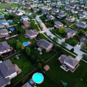
Efficient, cost-effective roofing work depends on your ability to quickly and accurately gather measurements and assess the current roof condition. Improve your responsiveness to customers by replacing countless site visits with online roof measuring tools using recent aerial photos. Take traffic and safety risk out of the equation and produce fast, accurate quotes with the power of high resolution aerial maps. 

It’s quite a challenge to fly over the right location during the perfect window in time late winter or early spring. You want the capture to be snow-free, but must act quickly before the trees go green. You also need cooperative clear skies and adequate daylight – more difficult during short winter days. However detailed aerial capture plans may be, survey teams must still adapt on the fly and follow opportunity. You must learn to adapt quickly, and nimbly deploy aerial assets as opportunities present.

Take Chicago, for example – the time between last snow and first bloom can often be measured in days, or at best a few weeks. Clear weather aerial capture is difficult, but the ability for roofers to accurately measure what’s typically obscured by nature is essential.

roof measurements

Aerial vs. Satellite vs. Drones

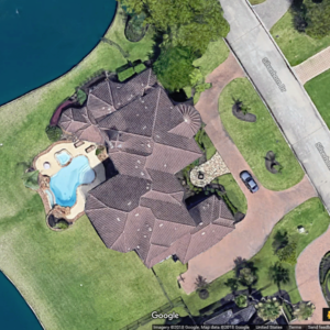
There has been a move away from the satellite imagery that dominated measuring and site-surveying for the previous decade. There’s a couple of reasons for this, the main one being quality. No matter how good the camera on a satellite may be, it’s still in outer space. By being closer to the earth’s surface,  a high-quality camera on an airplane is going to capture a clearer, sharper image. 

What about imagery from a drone? With drone-captured imagery, you have the same problem you have with satellite captures, distance. Drone cameras historically have had wide-angle lenses, causing distortion of rooflines at low altitudes. We have no problem with drone-captured imagery, it’s often the best, and sometimes the only source for rural addresses that lack coverage by satellite and aerial imagery. To overcome the distortion, we suggest flying your drone to a minimum altitude of 400 feet. At that height, any visible distortion should be negligible, and you can make good use of your up-to-date drone imagery! That leads us to our next point…

Roofing reports

3D Model, Because Only a Good Picture is Worth a Thousand Words

Aerial imagery provides distorted, flat one-dimensional images that are often taken at a poor viewing angle. HOVER’s technology creates a highly accurate interactive 3D model of your project that streamlines communication on the job. Whether you’re pitching a prospective client, planning with your superintendent or installation group, HOVER’s 3D model is an invaluable asset for your entire process, from sales through completion.

Simply put, aerial measurements cannot compare to the accuracy and detail available with Sky Roof Measure’s timely, convenient features. Save time and money and surpass your client’s expectations when you base your projects on Sky Roof Measure measurements and models.

Satellite roof measurements

Remote Aerial Roof Measurement is Here Today

It’s true that the nail gun didn’t replace the hammer. That said, no professional is going to attempt to put on a roof without an air compressor nearby. The same can be said for measuring roofs from your desk… it’ll never replace a measuring tape completely but it sure gives you a head start. Please, take a moment to learn how Sky Roof Measure can improve your bottom line while keeping you off unprofitable roofs. Aerial roof measurements are here. Now is the time to save time, money, and allow your business to run at a much higher profit margin.
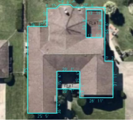
roof quotes online

Roof Measurements From Satellite

Aerial Measurements For Roofing Contractors and using Google Maps to get unlimited roof measurements can help any roofing contractor, and be more efficient. Most roofers feel like they need to go to every estimate and then measure the roof, and most of the time it’s a good idea to go to every estimate, but this free tool will give you the opportunity to do a little homework before you get to the job.

                            Call Us – (315) 926-1777

Satellite Roof Measurements 

Our  roofing contractors are able to receive measurements of any roof in a very short time with extreme accuracy without the need to visit your home or business. Our aim is to provide you with all the necessary information to enable you to make informed decisions. 

Saving Precious Time

It also happens that roofing issues can sometimes become roofing emergencies so utilizing satellite roof measurements can speed up the process of repairing your roof. There is no need to book appointments in advance to have our roofers visit your home in order to physically take measurements and conduct calculations in order to provide you with an accurate estimate. Our foam roofing experts receive all your roofing measurements electronically and prepare your free no-obligation estimate in the shortest time possible.

How Satellite Information Is Received 

Satellite roof measurements are based on satellite images sourced from Google application programming interfaces (APIs) that receive information and images from Google Earth. The information and images are used to calculate accurately both the square footage and slope of your roof. It is no longer necessary to have individuals climbing on your roof to take physical and time-consuming measurements.

The Roof Measurement Report provides a detailed analysis of your roof layout and all the critical dimensions. Our full color report provides the detailed lengths, pitch and areas of every surface plane and edge. This report saves your time and enables accurate roof estimates for a roof repair or replacement. This is a professional grade report used for use by licensed roofing contractors or insurance companies. You will receive the report in .PDF format by email within 1-3 days.

What factors determine the price of a roof?

Type of Roofing  –  The material type that you purchase for your roof affects the bid price. There is a basic 3 tab or 3 in 1 style, Architectural or Laminated (Most Common) and then you designer or premium level shingles. Each of the major manufacturers will have their own individual characteristics, the thicker the shingle the heavier it will be rated for durability.

Pitch – The steeper the roof the steeper the price! Steeper roofs require additional safety precautions and create slower installation speeds. This additional labor required will add to the total cost of the job.

Height – Similar to the roof’s pitch affect on price, the higher the roof typically the higher the price. Most companies will charge an additional amount for 2 or 3 story access.

Allowance For Growth And Change

Since technology has thrived over the past few years and is consistently growing and changing, using satellite imagery allows for the ability of homeowners and contractors to grow and change with reducing risk and potential damages that could occur when obtaining roof measurements. In addition by getting more accurate readings and measurements on the roofs, the expenses that are required are reduced as they are more accurately acquired and they take fewer visits to obtain the calculation or measurements. In addition, satellite measurements have the ability to give homeowners the exact square footage even though the slopes and steeps of the home. This can increase contractors companies proficiency and accuracy to help homeowners increase the longevity of their homes because the repairs will be done more professionally. Moreover, contractors and homeowners can measure roof from a satellite for free with the programs that are available online, thus saving them time, claims, flexibility, and materials for roofing jobs.